Know the island
Saba is what happens when a Caribbean island refuses to be a beach resort.
Nearly every road climbs, the coastline drops into deep blue water and the most famous attractions are beneath the sea or inside a cloud forest. Saba rewards active travelers, experienced divers and people who value a close-knit village over nightlife. It is not a lesser version of St. Maarten; it is a completely different kind of Caribbean trip.
A brief history
Indigenous peoples visited or inhabited Saba before Europeans arrived. Columbus sighted the island in 1493, but its cliffs discouraged immediate settlement. Dutch settlers established a lasting community in the 1600s, while control shifted several times among European powers. Plantation agriculture and maritime trade relied in part on enslaved African labor; emancipation in the Dutch colonies came in 1863.
Isolation shaped Saban life. Men became sailors and captains, women developed the fine needlework now called Saba lace, and cargo was carried up The Ladder from the sea. Engineer Josephus Lambert Hassell began building “The Road” in the 1930s despite expert claims that a road was impossible. Saba became a public body—a special municipality—of the Netherlands in 2010.
What Saba is most known for
Protected marine-park diving, deep volcanic pinnacles, Mount Scenery, cloud forest, the tiny Juancho E. Yrausquin Airport, red-roofed Saban cottages, The Road, The Ladder, Saba lace and an unusually intimate, conservation-minded community.
Geography
Saba covers about five square miles and is essentially the steep upper portion of a volcanic complex. Mount Scenery was remeasured at approximately 870 meters in 2024, making it the highest point in the Kingdom of the Netherlands. Cliffs replace broad beaches, deep water lies close offshore and the Saba Bank—a vast submerged platform—begins southwest of the island.
Plan your trip
The dry season is made for trails. Divers have reasons to come almost all year.
January–April
Drier air, cooler hiking conditions and the best odds for clear viewpoints. Winter swell can occasionally limit western dive sites or ferry comfort, so keep a flexible day in the plan.
May–July
Warmer, greener and often quieter, with good diving and increasing showers. July brings Carnival energy and a rising chance of tropical weather, so protect connections and prepaid activities.
August–November
Higher humidity, wetter trails and peak hurricane exposure. October’s Sea & Learn programming can be excellent, but build in disruption protection.
Is Saba hurricane-safe?
No. Atlantic hurricane season runs June through November, and a small island with one short runway and a weather-sensitive harbor has fewer backup routes than a major hub. Choose flexible flights, protect prepaid diving and allow a buffer before the international trip home.
How to get there
St. Maarten is the main gateway. Choose twelve minutes in the air or roughly ninety on the sea.
WINAIR from St. Maarten
The flight from SXM to Saba takes about 12–15 minutes on a small Twin Otter. Landing on Saba’s famously short runway is dramatic but routine for specially trained crews. Weather, weight and visibility can move bags or flights, so pack essentials in your personal item.
The Edge
The Edge currently runs direct between Simpson Bay and Fort Bay on Tuesdays and Fridays, taking about 90 minutes in ordinary conditions. The same-day schedule can support a day trip, but an overnight stay is far more resilient and rewarding.
Makana
Makana links Saba with St. Maarten, St. Eustatius and St. Kitts on a changing weekly pattern. Current timetables include several Saba–St. Maarten sailings and useful Statia connections. Buy only from the live schedule for your date.
Statia & St. Kitts
St. Eustatius is the easiest additional island by ferry, with direct crossings around an hour on many scheduled days. St. Kitts is also reachable on selected Makana sailings. There is no dependable public ferry to St. Barthélemy, Anguilla or Nevis; route through St. Maarten or fly.
Choose your Saba
Windwardside is the easy answer. The hills are the private one.
Saba is compact, but “nearby” can still mean a steep road and several hundred feet of elevation. Most first-time visitors should prioritize walkable dinners over saving a few minutes to the harbor.
Best overall · walkable dining, trails & island character
Windwardside
Most visitors should stay here. Traditional white cottages with red roofs sit beneath Mount Scenery, while restaurants, groceries, museums and the Trail Shop are close enough to reach on foot. Dive operators collect guests for the drive to Fort Bay.
- Nearby
- Mount Scenery trailhead, museums, Trail Shop, restaurants
- Consider
- Juliana’s Hotel, Cottage Club, El Momo Cottages, Scenery Hotel
Best for quiet luxury, local life & the capital
Troy Hill & The Bottom
The Bottom is Saba’s administrative center and the home of its medical school, hospital and several local restaurants. Villas and Queen’s Hotel sit higher on Troy Hill with sweeping views, but steep roads make taxis or a rental more important.
- Nearby
- The Ladder, Sacred Heart Church, hospital, Fort Bay road
- Consider
- Queen’s Hotel, Troy Hill villas, apartments and guesthouses
Best for cottages, privacy & views near Windwardside
Booby Hill & English Quarter
These green hills feel secluded without placing you far from Windwardside. They suit travelers who want a cottage, kitchen or private terrace, but the slopes are steeper than the short map distances suggest.
- Nearby
- Windwardside, Spring Bay trail, mountain views
- Consider
- El Momo area cottages, Haiku House, Flamboyant Cottage and private villas
Best for airport drama, local neighborhoods & solitude
Zion’s Hill & St. Johns
Zion’s Hill—traditionally called Hell’s Gate—looks over the airport and northeastern coast. St. Johns lies between Windwardside and The Bottom. Both feel residential and quiet; lodging and evening dining are limited, so arrange transport.
- Nearby
- Airport overlook, Sandy Cruz access, Cove Bay, Flat Point
- Consider
- Small guesthouses, apartments and locally managed cottages
Swimming without a beach itinerary
Saba has beautiful water. It barely has beaches.
The steep volcanic coast is central to Saba’s character and its diving. There are no broad, reliable sandy strands, no beach clubs and no reason to pack a different swimsuit for every day. Water access is condition-dependent and mostly unguarded.
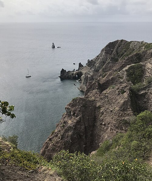
Wells Bay · the wandering beach
Saba’s most beach-like shoreline may be black sand, cobble or almost absent depending on swell. Swim only in calm conditions and ask locally that morning; there is no lifeguard or predictable beach width.
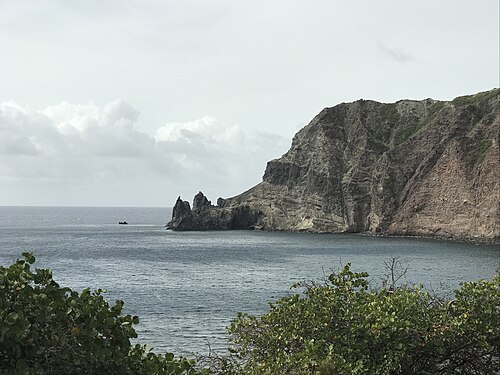
Torrens Point
A protected-looking cove with volcanic spires, tunnels and rewarding shallow marine life. The best access is usually by dive or snorkel boat.
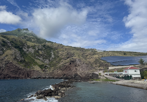
Cove Bay & Flat Point
The volcanic coast below the airport has tide pools and an easy overlook walk. Rough-sea and riptide advisories are common; never climb down when the trail advisory warns against it.
Fort Bay
The working harbor has occasional small black-sand pockets and water access, but ferries, dive boats, surge and commercial activity make it a port.
Diamond Rock & Man O’ War Shoals
These offshore formations are boat-access dive and snorkel highlights in suitable seas, with clear water, coral-covered rock and abundant fish life.
Around Green Island
The northeastern islet and nearby reef are reached by licensed boat. Exposure, current and protected marine habitat make this an operator-led outing, not a self-guided swim.
Cliffs make accumulation less trip-defining.
Checked July 29, 2026
NOAA’s regional monitoring indicates an exceptionally large 2026 Caribbean season. Saba’s sheer cliffs and lack of broad shallow beaches mean sargassum is usually less trip-defining here than on low, east-facing islands. It can still collect around Cove Bay, Fort Bay and temporary shoreline pockets, affect odor or water access and move with wind in hours.
For divers, sea state and visibility are usually more consequential than beach accumulation. Ask the operator for the same-day site plan.
The experiences that explain the island
Saba’s most worthwhile tours.
There are few mass-market excursions. The best experiences are small, weather-aware and led by people who understand the island’s geology, ecology and community.
Two- or three-tank marine-park day
The essential Saba experience for certified divers. Ask the operator to balance an iconic pinnacle with a shallower reef or volcanic site suited to your certification, recent conditions and no-fly time.
Mount Scenery with a guide
Climb from Windwardside through rainforest into cloud forest. A guide adds natural history and can adjust when wet steps, wind or cloud make the summit less straightforward.
Island taxi tour
See The Road, the airport overlook, Zion’s Hill, Windwardside, The Bottom, Fort Bay and village viewpoints while hearing how Sabans built an island once declared too steep for a road.
Sandy Cruz + Elfin Forest hike
One of the strongest alternatives to the summit, with rainforest, old farmland and a route into the high-elevation forest. Arrange a taxi between trailheads when hiking point to point.
Torrens Point snorkel
Explore volcanic formations and fish life from a licensed boat in calm weather. It is the most convincing answer for non-divers who still want Saba’s marine side.
The Ladder
Walk the historic stone steps once used to haul nearly every arrival from Ladder Bay to The Bottom. The story is fascinating; the climb back is a very literal history lesson.
Museums of Windwardside
Pair the Harry L. Johnson Museum, Dutch Museum and Saba Heritage Center according to current opening days. Small collections make more sense with local conversation.
Art, lace & Saba Spice
Visit island artists, look for the distinctive handwork known as Saba lace and sample the local spiced-rum tradition. Confirm workshop and tasting hours in advance.
Sunset or coastal boat trip
A private or small-group outing reveals the cliffs, Ladder Bay and volcanic profile that roads cannot. Sea state determines whether it is serene or sensibly postponed.
Sea & Learn event
When the annual program is running, visiting scientists lead field trips, talks and hands-on nature experiences. The schedule changes yearly and deserves advance planning.
On & under the water
The marine park is the headline—and the pinnacles earn it.
Deep-sea fishing
Saba does not have a dependable visitor-oriented deep-sea charter fleet. The surrounding water is deep and pelagic fish are present, but the island’s small harbor, marine-park priorities and limited boats make offshore fishing difficult to arrange as a conventional tourist excursion.
Best timing: Only book if a currently licensed local operator confirms the trip and marine-park rules. Travelers primarily interested in big-game fishing should charter from St. Maarten, St. Kitts or St. Thomas and keep Saba focused on diving and hiking.
Scuba diving
Saba National Marine Park surrounds the island and protects more than 30 named sites using permanent moorings. The signature dives are offshore volcanic pinnacles: Third Encounter, Twilight Zone, Outer Limits, Mount Michel and Shark Shoals. Their tops begin deep, current can be meaningful and several profiles suit experienced divers using nitrox.
Tent Reef offers walls, boulders, channels and excellent night diving close to Fort Bay. Ladder Bay mixes volcanic ridges, warm sand and macro life. Diamond Rock, Man O’ War Shoals and Torrens Point provide shallower scenery and longer bottom times, while the windward sites hold Saba’s more traditional hard-coral reef formations.
Likely—not promised—encounters include Caribbean reef and nurse sharks, turtles, rays, large groupers, jacks, barracuda, lobster, octopus, nudibranchs and enormous barrel sponges. Hammerheads and other large pelagics are occasional bonuses, not a booking guarantee.
Snorkeling
Saba is stronger for diving than casual shore snorkeling. Torrens Point and Wells Bay can be excellent in settled water; boat access improves safety and expands the options around Diamond Rock, Man O’ War Shoals or Green Island. There are few easy entries, no broad lagoon and no lifeguards. A guided boat is worth more here than an ambitious pin on a map.
Sailing
Saba is a spectacular but exposed cruising stop. Visiting yachts use yellow Marine Park moorings off Fort Bay or Ladder Bay on a first-come basis; current SCF guidance limits them to vessels up to 20 meters or 50 tons and stays of up to seven days. Dive moorings are not yacht moorings. Anchoring on coral is prohibited.
Fort Bay is the port of entry. Contact the harbormaster on VHF 16, complete customs and immigration and pay current harbor or park charges before settling in. Landing can be uncomfortable or impossible in swell, and the moorings do not offer marina-style shelter. Provision, fuel and complete repairs in St. Maarten; Saba’s groceries and marine services are limited.
Surfing
Saba is not a surf destination. The coastline is cliffy, entries are difficult, breaks are inconsistent and there is no meaningful rental or school scene. Strong swell is more likely to cancel a dive or ferry than produce a sensible visitor surf day. Surfers should base in St. Maarten, St. Barthélemy or a more established regional destination.
Cloud forest, craft & community
Hiking is not the activity between dives. It is half the reason to come.
Culture
English is the everyday language, with Dutch used in government and education. Saban speech and family histories connect the island to the wider English-speaking Caribbean, the Netherlands and generations of seafaring. Traditional cottages are typically white with red roofs and green shutters, adapted to steep terrain and storms.
Saba lace developed from nineteenth-century needlework and became an important home industry. Saba Spice is a family-style spiced-rum tradition. Saba Day in early December, summer carnival, church life, dominoes, music and community fundraisers reveal an island where participation matters more than spectacle.
Food
Fresh Saban lobster is the signature when in season and available. Also look for goat, fish, johnnycakes, rice dishes, Caribbean stews and imported Dutch influences. Nearly everything arrives by boat or small aircraft, so flexibility is part of dining well.
Mount Scenery
The main route begins opposite the Trail Shop in Windwardside and climbs roughly 1,064 wet stone steps. Allow around 2½–3 hours round trip, longer for photographs and careful footing. The upper cloud forest is often misty; a clear summit is a gift, not a contractual obligation. Hiking poles and shoes with grip are strongly recommended.
More trails
Sandy Cruz crosses lush forest between Zion’s Hill and Troy Hill. Mas’ Cohone’s Hill gives a short viewpoint alternative. The Ladder, Parish Hill, Spring Bay, Giles Quarter and the Elfin Forest add history, dry coast and high forest. At this review, the North Coast Trail remains closed until further notice. Flat Point tide-pool access can close in rough seas.
Read the current SCF advisory before every hike. Rain makes steps slick, cliff edges erode and several point-to-point routes need a taxi pickup. Caves and remote north-coast terrain require qualified guidance.
The annual calendar
Three small-island events with remarkably different personalities.
Saba moves from Carnival's exuberance to a month of nature-led learning, then closes the year by celebrating the island itself. Because rooms, flights and ferries are limited, event travel here rewards planning much earlier than the crowd size might suggest.
Late July–early August · The Bottom & island-wide
Saba Carnival
Nightly entertainment, food, pageants, J'Ouvert and colorful parades turn the island's close-knit community into its biggest annual party.October · Locations across Saba
Sea & Learn on Saba
Visiting experts lead talks, hikes, dives and field activities exploring coral reefs, sharks, birds, geology and Saba's cloud forest.Early December · Island-wide
Saba Day Weekend
Ceremonies, music, dance, food and community activities celebrate Saban heritage and the island's national day.Restaurants & hotels
A surprisingly good dining scene—on a very small weekly calendar.
Restaurants are intimate and independently run. Opening nights change, supplies arrive by sea and reservations matter. Ask your hotel to map the week before arrival, especially when diving leaves you hungry at exactly the wrong closed door.
Brigadoon for refined Caribbean and international cooking; Tropics Café, The Hideaway and changing hotel dining for relaxed evenings
Bizzy B Bakery for breakfast and lunch, Amonhana for pizza and casual plates, plus cafés and snack bars around the village
Island Flavor, Saba Snack Gourmet, Maribel’s and small local kitchens—confirm the exact day and cash policy
Saban lobster when available, barbecue nights, johnnycakes, fresh fish, Saba Spice and Deep Dive Brewing beer
Hotel strategy
Book for location before amenities.
Best first stay
Juliana’s and Cottage Club place you within Windwardside’s easiest walking radius. Scenery Hotel adds a newer boutique option at the foot of Mount Scenery.
More independent
El Momo’s simple garden cottages suit budget-minded, stair-capable travelers. Traditional cottages and villas offer kitchens, privacy and the strongest residential feel.
Quiet luxury
Queen’s Hotel on Troy Hill trades walkability for larger suites, views and a secluded atmosphere above The Bottom. Confirm dining and transfers.
Practical details
Tiny, friendly and easy to understand—provided you respect the slopes and schedules.
English is universal in daily life. Dutch appears in government and formal settings.
USD is the official currency. There is no exchange calculation for U.S. visitors.
Cards work at many hotels and restaurants. Carry cash for taxis, trail donations and small purchases.
North American plugs are standard. Ask lodging about backup power for outages.
Desalinated Saba Splash water is safe. Many buildings also use cisterns; ask whether a particular tap is treated.
Visitors usually rely on taxis. The Road is steep, narrow and best left to experienced local drivers.
Cash & cards
Hotels and larger restaurants commonly accept cards, but cash is essential for taxis, small eateries, tips and outages. There are few ATMs and no useful backup island when one is down. Bring clean U.S. notes.
Transportation
Traffic drives on the right. Taxis are the easiest choice: drivers know flight, ferry, dive and trail timing, and many provide island tours. Rental cars exist, but The Road is narrow, steep and edged by cliffs; parking is limited and automatic inventory can be small. Walking works within Windwardside, not between most villages with luggage.
Safety
Crime is low, though ordinary care still applies. The meaningful visitor risks are wet stairs, cliff edges, heat, rough water, decompression illness and transport disruption. Do not hike closed trails, enter tide pools under a rough-sea advisory or schedule a flight before completing the dive operator’s required surface interval.
Health & vaccines
Be current on routine vaccines and review CDC advice for your health and itinerary. Mosquito protection matters for dengue and other mosquito-borne illness. Saba has a hospital and a hyperbaric facility, but specialty and emergency capacity are limited; serious cases may require evacuation to St. Maarten. Divers should carry appropriate accident and evacuation coverage.
Research desk
Official sources & live checks
Saba’s experience depends on weather and a small number of operators. These official and specialist sources are the essential final check.